It is important for a pilot to know the direction of the wind. At facilities with an operating control tower, this information is provided by ATC. Information may also be provided by FSS personnel either located at a particular airport or remotely available through a remote communication outlet (RCO), or by requesting information on a CTAF at airports that have the capacity to receive and broadcast on this frequency.
When none of these services is available, it is possible to determine wind direction and runway in use by visual wind indicators. A pilot should check these wind indicators even when information is provided on the CTAF at a given airport because there is no assurance that the information provided is accurate.
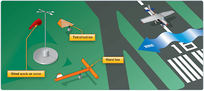
The wind direction indicator can be a wind cone, wind sock, tetrahedron, or wind tee. These are usually located in a central location near the runway and may be placed in the center of a segmented circle, which identifies the traffic pattern direction if it is other than the standard left-hand pattern. [Figures 1 and 2]
 |
| Figure 1. Wind direction indicators |
 |
| Figure 2. Segmented circle |
