To illustrate some of the concepts introduced the IFR Flight, follow along on a typical IFR flight from the Birmingham International Airport (BHM), Birmingham, Alabama to Gulfport-Biloxi International Airport (GPT), Gulfport, Mississippi. [Figure 1] For this trip, a Cessna 182 with a call sign of N1230A is flown. The aircraft is equipped with dual navigation and communication radios, a transponder, and a GPS system approved for IFR en route, terminal, and approach operations.
 |
| Figure 1. Route planning |
Preflight
The success of the flight depends largely upon the thoroughness of the preflight planning. The evening before the flight, pay close attention to the weather forecast and begin planning the flight. The Weather Channel indicates a large, low-pressure system has settled in over the Midwest, pulling moisture up from the Gulf of Mexico and causing low ceilings and visibility with little chance for improvement over the next couple of days. To begin planning, gather all the necessary charts and materials, and verify everything is current. This includes en route charts, approach charts, DPs, STAR charts, the GPS database, as well as an A/FD, some navigation logs, and the aircraft’s POH/AFM. The charts cover both the departure and arrival airports and any contingency airports that will be needed if the flight cannot be completed as planned. This is also a good time for the pilot to consider recent flight experience, pilot proficiency, fitness, and personal weather minimums to fly this particular flight.
 |
| Figure 2. Departure procedure (DP) |
Next, call 1-800-WX-BRIEF to obtain an outlook-type weather briefing for the proposed flight. This provides forecast conditions for departure and arrival airports, as well as the en route portion of the flight including forecast winds aloft. This also is a good opportunity to check the available NOTAMs.
The weather briefer confirms the predictions of the Weather Channel giving forecast conditions that are at or near minimum landing minimums at both BHM and GPT for the proposed departure time. The briefer provides NOTAM information for GPT indicating that the localizer to runway 32 is scheduled to be out of service and that runway 18/36 is closed until further notice. Also check for temporary flight restrictions (TFRs) along the proposed route.
After receiving a weather briefing, continue flight planning and begin to transfer some preliminary information onto the navigation log, listing each fix along the route and the distances, frequencies, and altitudes. Consolidating this information onto an organized navigation log keeps the workload to a minimum during the flight.
Next, obtain a standard weather briefing online for the proposed route. A check of current conditions indicates low IFR conditions at both the departure airport and the destination, with visibility of one-quarter mile:
SURFACE WEATHER OBSERVATIONS
METAR KBHM 111155Z VRB04KT ¼ SM FG –RA VV004 06/05 A2994 RMK A02 SLP140
METAR KGPT 111156Z 24003KT ¼ SM FG OVC001 08/07 A2962 RMK A02 SLP033
The small temperature/dewpoint spread is causing the low visibility and ceilings. Conditions should improve later in the day as temperatures increase. A check of the terminal forecast confirms this theory:
TERMINAL FORECASTS
TAF KBHM 111156Z 111212 VRB04KT ¼ SM FG VV004 TEMPO1316 ¾ SM OVC004
FM2000 22008KT 3SM –RA OVC015 TEMP 2205 3SM –RA OVC025 FM0500 23013KT P6SM OVC025FM0800 23013KT P6SM BKN030 PROB40 1012 2SM BR OVC030
TAF KGPT 111153Z 111212 24004KT ¼ SM FG OVC001 BECMG 1317 3SM BR 0VC004
FM1700 24010KT 4SM –RA OVC006 FM0400 24010 5SM SCT080 TEMPO 0612 P6SM SKC
NRN LA, AR, NRN MS
SWLY WND THRUT THE PD. 16Z CIG OVC006. SCT –SHRA. OTLK… IFR SRN ½ … CIG SCT – BKN015 TOPS TO FL250 SWLY WND THRUT THE PD. 17Z AGL BKN040. OTLK…MVFR CIG VIS.
LA MS CSTL WTRS
CIG OVC001 – OVC006. TOPS TO FL240. VIS ¼ – ¾ SM FG. SWLY WND. 16Z CIG OVC010 VIS 2 SM BR. OCNL VIS 3-5SM –RN BR OVC009. OTLK…MVFR CIG VIS.
FL
CIG BKN020 TOPS TO FL180. VIS 1–3 SM BR. SWLY WND. 18Z BRK030. OTLK…MVFR CIG.
At this time, there are no SIGMETs or PIREPs reported. However, there are several AIRMETs, one for IFR conditions, one for turbulence that covers the entire route, and another for icing conditions that covers an area just north of the route:
WAUS44 KKCI 111150
DFWS WA 0111150
AIRMET SIERRA FOR IFR VALID UNTIL 111800
AIRMET IFR…OK TX LA AR MS AL FL TS IMPLY SEV OR GTR TURB SEV ICE LLWS AND IFR CONDS.
NON MSL HGHTS DENOTED BY AGL OR CIG.
A recheck of NOTAMs for Gulfport confirms that the localizer to runway 32 is out of service until further notice and runway 18/36 is closed. If runway 6 is planned for the departure, confirm that the climb restriction for the departure can be met.
GPT 12/006 GPT LOC OS UFN
GPT 12/008 GPT MIRL RWY 18/36 OS UFN
Since the weather is substantially better to the east, Pensacola Regional Airport is a good alternate with current conditions and a forecast of marginal VFR.
METAR KPNS 111150Z 21010Z 3SM BKN014 OVC025 09/03 A2973
TAF KPNS 111152Z 111212 22010KT 3 SM BR OVC020 BECMG 1317 4 SM BR OVC025
FM1700 23010KT 4SM –RA OVC030
FM 0400 25014KT 5SM OVC050 TEMPO1612 P6SM OVC080
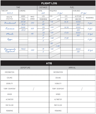
If weather minimums are below a pilot’s personal minimums, a delay in departure to wait for improved conditions is a good decision. This time can be used to complete the navigation log, which is the next step in planning an IFR flight. [Figure 3]
 |
| Figure 3. Navigation log |
Use the POH/AFM to compute a true airspeed, cruise power setting, and fuel burn based on the forecast temperatures aloft and cruising pressure altitude. Also, compute weightand- balance information and determine takeoff and landing distances. There will be a crosswind if weather conditions require a straight-in landing on runway 14 at GPT. Therefore, compute the landing distance assuming a 10-knot crosswind and determine if the runway length is adequate to allow landing. Determine the estimated flight time and fuel burn using the winds aloft forecast and considering Pensacola Regional Airport as an alternate airport. With full tanks, the flight can be made nonstop with adequate fuel for flight to the destination, alternate, and the reserve requirement.
 |
| Figure 4. Flight plan form |
Call an FSS for an updated weather briefing. Birmingham INTL airport is now reporting 700 overcast with 3 miles visibility, and Gulfport-Biloxi is now 400 overcast with 2 miles visibility. The alternate, Pensacola Regional Airport, continues to report adequate weather conditions with 2,000 overcast and 3 miles visibility in light rain.
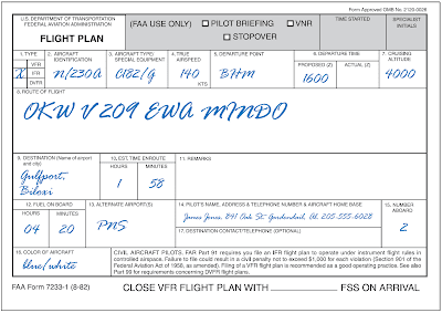
Several pilot reports have been submitted for light icing conditions; however, all the reports are north of the route of flight and correspond to the AIRMET that was issued earlier. No pilot reports have included cloud tops, but the area forecast predicted cloud tops to flight level 240. Since the weather conditions appear to be improving, a flight plan can be filed using the completed form.
Analyze the latest weather minimums to determine if they exceed personal minimums. With the absence of icing reported along the route and steadily rising temperatures, structural icing should not be a problem. Make a note to do an operational check of the pitot heat during preflight and to take evasive action immediately should even light icing conditions be encountered in flight. This may require returning to BHM or landing at an intermediate spot before reaching GPT. The go/no-go decision is constantly reevaluated during the flight.
Once at the airport, conduct a thorough preflight inspection. A quick check of the logbooks indicates all airworthiness requirements have been met to conduct this IFR flight including an altimeter, static, and transponder test within the preceding 24 calendar months. In addition, a log on the clipboard indicates the VOR system has been checked within the preceding 30 days. Turn on the master switch and pitot heat, and quickly check the heating element before it becomes too hot. Then, complete the rest of the walk-around procedure. Since this is a flight in actual IFR conditions, place special emphasis on IFR equipment during the walk-around, including the alternator belt and antennas. After completing the preflight, organize charts, pencils, paper, and navigation log in the flight deck for quick, easy access. This is also the time to enter the planned flight into the GPS.
Departure
After starting the engine, tune in ATIS and copy the information to the navigation log. The conditions remain the same as the updated weather briefing with the ceiling at 700 overcast and visibility at 3 miles. Call clearance delivery to receive a clearance:
“Clearance Delivery, Cessna 1230A IFR to Gulfport Biloxi with information Kilo, ready to copy.”
“Cessna 1230A is cleared to Gulfport-Biloxi via the Birmingham Three Departure, Brookwood, Victor 209 Kewanee then direct Mindo, Gulfport. Climb and maintain 4,000. Squawk 0321.”
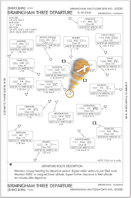
Read back the clearance and review the DP. Although a departure frequency was not given in the clearance, note that on the DP, the departure control frequency is listed as 123.8 for the southern sector. Since a departure from runway 24 is anticipated, note the instruction to climb to 2,100 prior to turning. After tuning in the appropriate frequencies and setting up navigation equipment for the departure routing, contact ground control (noting that this is IFR) and receive the following clearance:
“Cessna 1230A taxi to runway 24 via taxiway Mike.”
Read back the clearance and aircraft call sign. After a review of the taxi instructions on the airport diagram, begin to taxi and check the flight instruments for proper indications.
Hold short of runway 24 and complete the before takeoff checklist and engine run-up. Advise the tower when ready for takeoff. The tower gives the following clearance:
“Cessna 30A cleared for takeoff runway 24. Caution wake turbulence from 737 departing to the northwest.”
Taxi into position. Note the time off on the navigation log, verify that the heading indicator and magnetic compass are in agreement, the transponder is in the ALT position, all the necessary lights, equipment, and pitot heat are on. Start the takeoff roll. To avoid the 737’s wake turbulence, make note of its lift off point and take off prior to that point.
After departure, climb straight ahead to 2,100 feet as directed by the Birmingham Three Departure. While continuing a climb to the assigned altitude of 4,000 feet, the following instructions are received from the tower:”Cessna 30A contact Departure.”
Acknowledge the clearance and contact departure on the frequency designated by the DP. State the present altitude so the departure controller can check the encoded altitude against indicated altitude:
“Birmingham Departure Cessna 1230A climbing through 2,700 heading 240.”
Departure replies:
“Cessna 30A proceed direct to Brookwood and resume own navigation. Contact Atlanta Center on 134.05.”
Acknowledge the clearance, contact Atlanta Center and proceed direct to Brookwood VORTAC, using the IFR approved GPS equipment. En route to Kewanee, VORTAC Atlanta Center issues the following instructions:
“Cessna 1230A contact Memphis Center on 125.975.”
Acknowledge the instructions and contact Memphis Center with aircraft ID and present altitude. Memphis Center acknowledges contact:
“Cessna 1230A, Meridian altimeter is 29.87. Traffic at your 2 o’clock and 6 miles is a King Air at 5,000 climbing to 12,000.”
Even when on an IFR flight plan, pilots are still responsible for seeing and avoiding other aircraft. Acknowledge the call from Memphis Center and inform them of negative contact with traffic due to IMC.
“Roger, altimeter setting 29.87. Cessna 1230A is in IMC negative contact with traffic.”
Continue the flight, and at each fix note the arrival time on the navigation log to monitor progress.
“Greenwood Radio, Cessna 30A is currently 30 miles south of the Kewanee VORTAC at 4,000 feet en route to Gulfport. Requesting an update of en route conditions and current weather at GPT, as well as PNS.”
“Cessna 30A, Greenwood Radio, current weather at Gulfport is 400 overcast with 3 miles visibility in light rain. The winds are from 140 at 7 and the altimeter is 29.86. Weather across your route is generally IFR in light rain with ceilings ranging from 300 to 1,000 overcast with visibilities between 1 and 3 miles. Pensacola weather is much better with ceilings now at 2,500 and visibility 6 miles. Checking current NOTAMs at GPT shows the localizer out of service and runway 18/36 closed.”
“Roger, Cessna 30A copies the weather. I have a PIREP when you are ready to copy.”
“Cessna 30A go ahead with your PIREP.”
“Cessna 30A is a Cessna 182 located on the Kewanee 195° radial at 30 miles level at 4,000 feet. I am currently in IMC conditions with a smooth ride. Outside air temperature is plus 1° Celsius. Negative icing.”
“Cessna 30A thank you for the PIREP.”
With the weather check and PIREP complete, return to Memphis Center:
“Memphis Center, Cessna 1230A is back on your frequency.”
“Cessna 1230A, Memphis Center, roger, contact Houston Center now on frequency 126.8.”
“Roger, contact Houston Center frequency 126.8, Cessna 1230A.”
“Houston Center, Cessna 1230A level at 4,000 feet.”
“Cessna 30A, Houston Center area altimeter 29.88.”
Arrival
40 miles north of Gulfport, tune in ATIS on number two communication radio. The report reveals there has been no change in the weather and ATIS is advertising ILS runway 14 as the active approach.
Houston Center completes a hand off to Gulfport approach control with instructions to contact approach:
“Gulfport Approach, Cessna 1230A level 4,000 feet with information TANGO. Request GPS Runway 14 approach.”
“Cessna 30A, Gulfport Approach, descend and maintain 3,000 feet.”
“Descend to 3,000, Cessna 30A.”
Read back the clearance and concentrate on flying the aircraft. At MINDO descend to 2,000 as depicted on the approach chart. At BROWA turn to the final approach course of 133°. Just outside the Final Approach Way Point (FAWP) AVYUM, the GPS changes to the approach mode and the CDI becomes even more sensitive. Gulfport approach control issues instructions to contact Gulfport tower:
“Cessna 30A contact Tower on 123.7.”
“123.7, Cessna 30A.”
“Tower, Cessna 1230A outside AVYUM on the GPS runway 14.”
“Cessna 30A Gulfport Tower, the ceiling is now 600 overcast and the visibility is 4 miles.”
“Cleared to land runway 14, Cessna 30A.”
Continue the approach, complete the appropriate checklists, cross AVYUM, and begin the final descent. At 700 feet MSL visual contact with the airport is possible. Slow the aircraft and configure it to allow a normal descent to landing. As touch down is completed, Gulfport Tower gives further instructions:
“Cessna 30A turn left at taxiway Bravo and contact ground on 120.4.”
“Roger, Cessna 30A.”
Taxi clear of the runway and complete the appropriate checklists. The tower automatically cancels the IFR flight plan.
